
Asian side · Istanbul
How to get to Şile
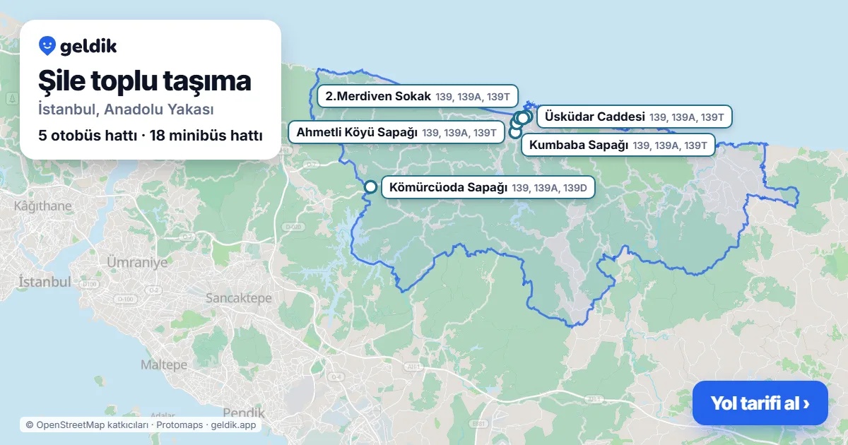
Şile has no metro, Marmaray or Metrobus station; you get there by bus or minibus. Nearest rail station: Sultanbeyli (~36.8 km from the centre). From Taksim about 3 h 3 min, 2 transfers.
- 0rail stations
- 5bus lines
- 18minibus lines
- 164bus stops
How long does it take to get to Şile?
Weekday 10:00 to the centre of Şile, using scheduled timetables; walking included, full Istanbulkart fare with transfer discounts. Bus and minibus times depend on traffic.
| From | Time | Route | Fare |
|---|---|---|---|
| Taksim | 3 h 3 min · 2 transfers |  E-3139TTaksim → Tedaş Önü | separate fare |
| Sultanahmet | 3 h · 2 transfers |   139TSirkeci → Tedaş Önü | separate fare |
| Kadıköy | 2 h 43 min · 1 transfer | HVL-6139TKadıköy (Havaist) → Tedaş Önü | separate fare |
| Üsküdar | 2 h 22 min · 1 transfer | 139TÜsküdar → Tedaş Önü | separate fare |
| Mecidiyeköy | 2 h 53 min · 1 transfer | 122C139TBahçeler Sokak → Tedaş Önü | separate fare |
| Yenikapı | 2 h 21 min · 2 transfers | 139TYenikapı → Tedaş Önü | separate fare |
| Istanbul Airport | 2 h 57 min · 3 transfers |  52211A139Tİstanbul Havalimanı → Tedaş Önü | separate fare |
| Sabiha Gökçen Airport | 2 h 42 min · 1 transfer | E-3139TSabiha Gökçen Havalimanı → Tedaş Önü | separate fare |
| Esenler Bus Terminal | 3 h 2 min · 3 transfers |  139TOtogar → Tedaş Önü | separate fare |
Calculated by the Geldik journey planner (Metro İstanbul official timetable, İETT scheduled timetable, İBB minibus plan) for a weekday (Wednesday, scheduled timetable).
Is there a metro in Şile?
There is no metro, Marmaray or Metrobus station in Şile. The nearest one is Sultanbeyli (~36.8 km in a straight line from the centre); within the district you travel by bus or minibus.
Buses in Şile (5 lines)
Minibuses in Şile (18 lines)
Minibus line pages are in Turkish.
- ŞL01Ağva – Değirmençayırı
- ŞL02Şile Merkez – Çayırbaşı Köyü
- ŞL03Şile – Kumbaba – Meşrutiyet Köyü – Ahmetli TOKİ
- ŞL04Şile Merkez – Ring – Plaj
- ŞL05Şile Dere Köyleri – Üsküdar
- ŞL06Şile – Kızılcaköy
- ŞL07Şile – Karamandere – İmrendere – Ovacık
- ŞL08Ağva – Bucaklı – Çelebiköy
- ŞL09Ağva – Göçe – Geredeli – Kalemköy
- ŞL10Şile – Değirmençayırı
- ŞL11Şile – Yeşilvadi – Üvezli – Ulupelit
- ŞL12Şile – Ahmetli TOKİ – Kızılcaköy
- ŞL13Şile – Karakiraz
- ŞL14Şile – Yazımanayır – Hacıllı – Ağva
- ŞL15Şile Merkez – Ağva
- ŞL16Şile Merkez – Ümraniye Metro Garden AVM
- ŞL17Şile – Kızılcaköy
- ŞL18Şile – Yazımanayır – Hacıllı – Ağva
Busiest bus stops in Şile
Stops served by the most lines. Stop pages (lines and next departures) are in Turkish.
- Kömürcüoda SapağıKömürlük · 4 lines
- Üsküdar CaddesiÇavuş · 3 lines
- Ahmetli Köyü SapağıKumbaba · 3 lines
- Kumbaba SapağıKumbaba · 3 lines
- Belediye Dinlenme TesisiKumbaba · 3 lines
- 2.Merdiven SokakÇavuş · 3 lines
- Bayrak CaddesiÇavuş · 3 lines
- Sedir SokakKumbaba · 3 lines
- Yeşilvadi SapağıSofular · 3 lines
- Kızılcaköy SapağıSofular · 3 lines
- Işık Üniversitesi KampüsüMeşrutiyet · 3 lines
- Meşrutiyet Köyü SapağıMeşrutiyet · 3 lines
- İhtisas CaddesiKumbaba · 3 lines
- Şile TerminalÇavuş · 3 lines
- Vasıf Topçu Fen LisesiMeşrutiyet · 3 lines
- Üvezli SapağıÜvezli · 4 lines
- Üvezli SapağıÜvezli · 4 lines
- Yakuplu SapağıAğva Merkez · 1 lines
- Yeşilçay Anadolu LisesiAğva Merkez · 1 lines
- Ağva MerkezAğva Merkez · 1 lines
- Kandıra SapağıAğva Merkez · 1 lines
- Sofular SapağıSofular · 3 lines
- Sofular SapağıSofular · 3 lines
- Tedaş ÖnüHacı Kasım · 1 lines
How to get to Şile from other districts
- From Adalar3 h 47 min · 3 transfers
- From Arnavutköy3 h 45 min · 2 transfers
- From Ataşehir2 h 24 min · 2 transfers
- From Avcılar3 h 43 min · 2 transfers
- From Bağcılar2 h 57 min · 3 transfers
- From Bahçelievler3 h 4 min · 3 transfers
- From Bakırköy3 h · 2 transfers
- From Başakşehir3 h 42 min · 3 transfers
- From Bayrampaşa3 h 3 min · 3 transfers
- From Beşiktaş3 h 4 min · 2 transfers
- From Beykoz2 h 44 min · 1 transfer
- From Beylikdüzü4 h 7 min · 3 transfers
- From Beyoğlu3 h 3 min · 2 transfers
- From Büyükçekmece4 h 7 min · 3 transfers
- From Çatalca4 h 57 min · 3 transfers
- From Çekmeköy1 h 50 min · direct
- From Esenler3 h 3 min · 3 transfers
- From Esenyurt4 h 5 min · 3 transfers
- From Eyüpsultan3 h 3 min · 3 transfers
- From Fatih3 h 2 min · 3 transfers
- From Gaziosmanpaşa3 h 3 min · 3 transfers
- From Güngören3 h 6 min · 3 transfers
- From Kadıköy2 h 41 min · 1 transfer
- From Kağıthane3 h 4 min · 2 transfers
- From Kartal2 h 57 min · 1 transfer
- From Küçükçekmece2 h 56 min · 2 transfers
- From Maltepe3 h 2 min · 2 transfers
- From Pendik3 h · 3 transfers
- From Sancaktepe2 h 4 min · 1 transfer
- From Sarıyer3 h 4 min · 3 transfers
- From Silivri4 h 56 min · 3 transfers
- From Sultanbeyli2 h 6 min · 2 transfers
- From Sultangazi3 h 23 min · 2 transfers
- From Şişli3 h 3 min · 2 transfers
- From Tuzla3 h 44 min · 3 transfers
- From Ümraniye1 h 58 min · direct
- From Üsküdar2 h 23 min · 1 transfer
- From Zeytinburnu3 h · 2 transfers
From Şile to other districts (38)
- To Adalar3 h 28 min
- To Arnavutköy3 h 30 min
- To Ataşehir2 h 10 min
- To Avcılar3 h 22 min
- To Bağcılar3 h 1 min
- To Bahçelievler3 h 7 min
- To Bakırköy2 h 46 min
- To Başakşehir3 h 26 min
- To Bayrampaşa2 h 54 min
- To Beşiktaş2 h 34 min
- To Beykoz2 h 39 min
- To Beylikdüzü3 h 46 min
- To Beyoğlu2 h 42 min
- To Büyükçekmece3 h 50 min
- To Çatalca4 h 30 min
- To Çekmeköy1 h 49 min
- To Esenler2 h 59 min
- To Esenyurt3 h 42 min
- To Eyüpsultan2 h 56 min
- To Fatih2 h 53 min
- To Gaziosmanpaşa3 h 5 min
- To Güngören3 h 14 min
- To Kadıköy2 h 26 min
- To Kağıthane2 h 49 min
- To Kartal2 h 41 min
- To Küçükçekmece3 h 3 min
- To Maltepe2 h 42 min
- To Pendik2 h 55 min
- To Sancaktepe1 h 52 min
- To Sarıyer2 h 59 min
- To Silivri4 h 14 min
- To Sultanbeyli2 h 6 min
- To Sultangazi3 h 17 min
- To Şişli2 h 44 min
- To Tuzla3 h 19 min
- To Ümraniye1 h 59 min
- To Üsküdar2 h 18 min
- To Zeytinburnu2 h 44 min
Neighbourhoods in Şile
Ağaçdere · Ağva Merkez · Ahmetli · Akçakese · Alacalı · Avcıkoru · Balibey · Bıçkıdere · Bozgoca · Bucaklı · Çataklı · Çavuş · Çayırbaşı · Çelebi · Çengilli · Darlık · Davutlu · Değirmen Çayırı · Doğancılı · Erenler · Esenceli · Evrenli · Geredeli · Göçe · Göçe Yeniköy · Gökmaşlı · Göksu · Hacı Kasım · Hacıkasım · Hacıllı · Hamitli · Hasanlı · İmrendere · İmrenli · İsaköy · Kabakoz · Kadıköy · Kalealtı · Kalem · Karabeyli · Karacaköy · Karakiraz · Karamandere · Kemalli · Kervansaray · Kılıçlar · Kızılcaköy · Koltu · Korucu · Kömürlük · Kumbaba · Kurfallı · Kurna · Manşar · Meşrutiyet · Oruçoğlu · Osmanköy · Ovacık · Sahilköy · Satmazlı · Sofular · Soğullar · Soğullu · Sortullu · Şuayipli · Teke · Ubeyli · Ulupelit · Üvezli · Yaka · Yakuplu · Yaylalı · Yazımanayır · Yeniköy · Yeşilvadi
Linked neighbourhoods open directions. Streets with their stops and lines: Şile streets (98, in Turkish).
Neighbouring districts
Frequently asked questions
Where is Şile?
Şile is a district on the Asian side of Istanbul; neighbouring districts: Beykoz, Çekmeköy, Pendik.
Is there a metro in Şile?
No, there is no metro, Marmaray or Metrobus station in Şile. The nearest rail station is Sultanbeyli, about 36.8 km in a straight line from the district centre.
How do I get from Taksim to Şile?
M2 (Taksim → 4.Levent), then E-3 bus (4.Levent Metro → Tepe Üstü), then 139T bus (Tepe Üstü → Tedaş Önü); about 3 h 3 min in total (weekday 10:00, scheduled timetable).
How do I get from Istanbul Airport to Şile?
M11 (İstanbul Havalimanı → Gayrettepe), then 522 bus (Köprülü Kavşak → Millet Bahçesi), then 11A bus (Millet Bahçesi → Plazalar), then 139T bus (Plazalar → Tedaş Önü); about 2 h 57 min in total.
Which buses go to Şile?
5 İETT bus lines stop in Şile; those with the most stops: 139A, 139T, 139S, 139D, 139.
Are there minibuses in Şile?
Yes, 18 minibus lines run through Şile: ŞL01, ŞL02, ŞL03, ŞL04, ŞL05, ŞL06, ŞL07, ŞL08, ŞL09, ŞL10.
District boundaries and centre: OpenStreetMap contributors (ODbL). Station districts verified with İBB open data.
Last updated: