
European side · Istanbul
How to get to Bakırköy
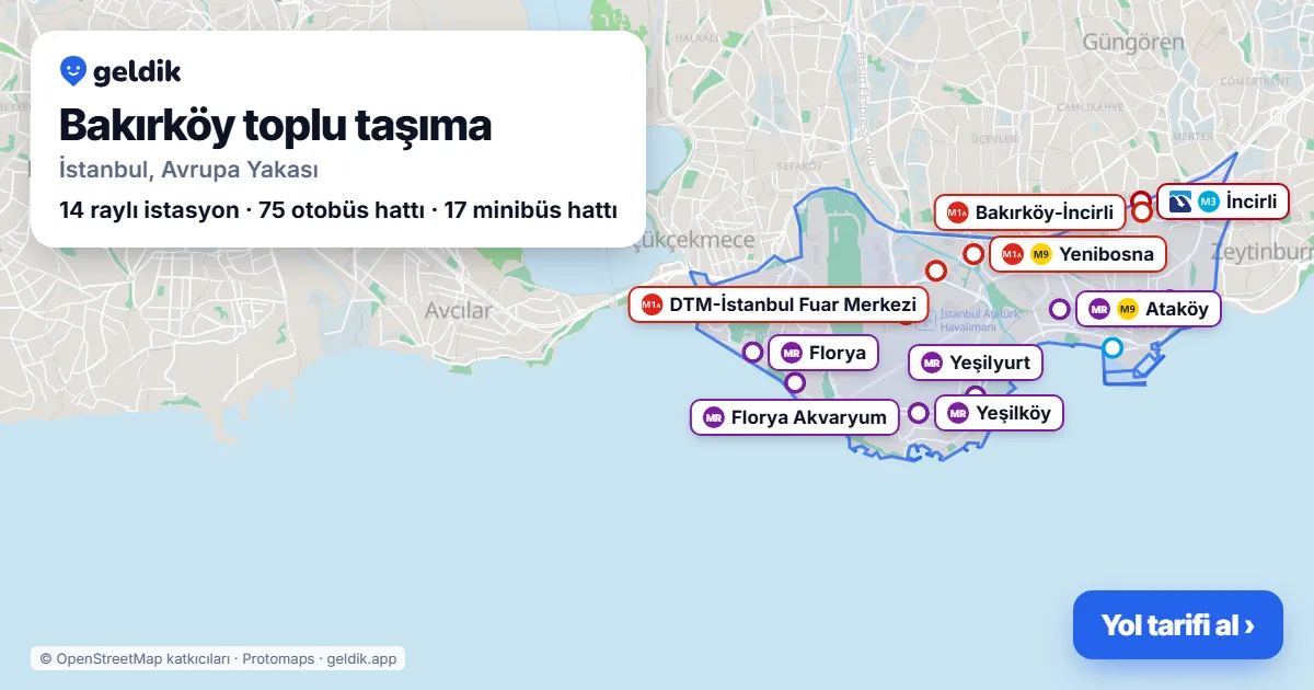
Bakırköy is on the rail network: 14 stations in the district (Metrobus, metro, Marmaray): İncirli, Florya, Florya Akvaryum, Yeşilköy, Yeşilyurt…. From Taksim about 37 min, 1 transfer.
- 14rail stations
- 75bus lines
- 17minibus lines
- 102bus stops
How long does it take to get to Bakırköy?
Weekday 10:00 to the centre of Bakırköy, using scheduled timetables; walking included, full Istanbulkart fare with transfer discounts. Bus and minibus times depend on traffic.
| From | Time | Route | Fare |
|---|---|---|---|
| Taksim | 37 min · 1 transfer |   Taksim → Bakırköy | 83.60 TL |
| Sultanahmet | 35 min · 1 transfer |  Sultanahmet → Bakırköy | 83.60 TL |
| Kadıköy | 41 min · 1 transfer |  Kadıköy → Bakırköy | 83.60 TL |
| Üsküdar | 27 min | Üsküdar → Bakırköy | 37.40 TL |
| Mecidiyeköy | 41 min · 1 transfer | Şişli-Mecidiyeköy → Bakırköy | 83.60 TL |
| Yenikapı | 20 min | Yenikapı → Bakırköy | 37.40 TL |
| Istanbul Airport | 1 h 15 min · 1 transfer |  İstanbul Havalimanı → Bakırköy | 95.63 TL |
| Sabiha Gökçen Airport | 1 h 23 min · 1 transfer | Sabiha Gökçen Havalimanı → Bakırköy | 83.60 TL |
| Esenler Bus Terminal | 29 min · 1 transfer |   Otogar → Özgürlük Meydanı | 80.60 TL |
Calculated by the Geldik journey planner (Metro İstanbul official timetable, İETT scheduled timetable, İBB minibus plan) for a weekday (Wednesday, scheduled timetable).
Metro, Metrobus and Marmaray stations in Bakırköy


Buses in Bakırköy (75 lines)
- 98MBakırköy – İstoç
- AVR1Atatürk Havalimanı – Bakırköy
- BN1Eminönü Mısır Çarşısı – Mehmetçik Sokak
- 79BBakırköy – Kayaşehir
- 98MBBakırköy – Marmara Sanayi Sitesi
- 72THarbiye Askeri Müze – Yeşilköy
- 146Bakırköy – Boğazköy Son Durak
- 97Aksaray Ring – 15 Temmuz Mahallesi Aile Sağlığı Merkezi
- 76VBakırköy – Vaditepe 1. Bölge
- 89YBBakırköy – Kanuni Sultan Süleyman
- 98SBakırköy – Kanuni Sultan Süleyman
- 89MZeytinburnu – Marmara Sanayi Sitesi
- 98ABakırköy – Göztepe Mahallesi
- 98BBakırköy – Kuyumcukent
- 98YBakırköy – Giyimkent
- 76Bakırköy – Beylikdüzü
- 98Bakırköy – Fenertepe Peronlar
- 98ABBakırköy – TOKİ Atakent Spor Lisesi
- 98TBBakırköy – Fatih Mahallesi
- 97KZZeytinburnu – İmam Mustafa Efendi Camii
- 98HBakırköy – Başakşehir Metrokent
- 98TBakırköy – Kanuni Sultan Süleyman
- 73Harbiye Askeri Müze – Yenibosna Metro
- E-57Bakırköy – Esenkent
- 73Yİstanbul Akvaryum – Kuyumcukent
- 98GBakırköy – Giyimkent
- 73Bİstanbul Akvaryum – Bakırköy
- 76DGümüşsuyu Peron – Bahçeşehir
- HT11Kuyumcukent – Giyimkent
- 73HYenibosna Metro – İst. Üni. Cerrahpaşa Tıp Fak. – Prof.dr.murat Dilmener Acil Durum Hst.
- HT13Zeytinburnu – Yeni Mahalle Metro
- 72YTYenikapı Etkinlik Alanı – İst. Üni. Cerrahpaşa Tıp Fak. – Prof.dr.murat Dilmener Acil Durum Hst.
- 50BZuhuratbaba – Alibeyköy Metro
- 73Fİstanbul Akvaryum – Harbiye Askeri Müze
- 31Yenikapı Etkinlik Alanı – Kuyumcukent
- 79GZeytinburnu – Kayaşehir
- 82Eminönü – Kuyumcukent
- 89BAksaray Peron – Küçükçekmece Anadolu Lisesi
- 71T10.Kısım – Harbiye Askeri Müze
- 98EBakırköy – Basın Tesisleri Son Durak
- 97EKazlıçeşme Marmaray – Bölge İdare Mahkemesi
- 31EEminönü – Kuyumcukent
- 98DBakırköy – Yeni Mahalle Metro
- MR20Kazlıçeşme Marmaray – Yenibosna Metro
- 34CEdirnekapı Garajı – B.sondurak
- 89AZeytinburnu – Kanuni Sultan Süleyman
- 89SZeytinburnu – Söğütlüçeşme
- 97BTHarbiye Askeri Müze – İtfaiye Okulu
- 89Aksaray Peron – Kanuni Sultan Süleyman
- 89KAksaray Peron – Kanuni Sultan Süleyman
- 79FYenibosna Metro – Kayaşehir
- 34Edirnekapı Garajı – Avcılar Mrk.ünv.kmp.
- 78ZBZeytinburnu – Fenertepe Peronlar
- HT20Yenibosna Metro – İgtot
- KÇ2Yenibosna Metro – Kanuni Sultan Süleyman
- HT10Yenibosna Metro – Batışehir
- 79KYenibosna Metro – Kayaşehir
- 34ASSöğütlüçeşme – Avcılar Mrk.ünv.kmp.
- 34BZZincirlikuyu – B.sondurak
- 34GB.sondurak – Söğütlüçeşme
- 36CYYenibosna Metro – Cebeci Peronlar
- 36AYYenibosna Metro – Arnavutköy Peronlar
- 93Eminönü – Zeytinburnu
- 93THarbiye Askeri Müze – Zeytinburnu
- 79YYenibosna Metro – Kayabaşı Kiptaş Peron
- MK97Zeytinburnu – Kerim Çavuşpaşa
- 97AEminönü – Basınsitesi
- 79FYYenibosna Metro – Fenertepe Peronlar
- 55YYenibosna Metro – Kağıthane Garajı
- 93MMecidiyeköy AVM – Zeytinburnu
- 78BYenibosna Metro – Fenertepe Peronlar
- 92Eminönü – Yeni Mahalle Metro
- 97THarbiye Askeri Müze – Basınsitesi
- HT12Yenibosna Metro – Basın Tesisleri Son Durak
- 500L4.Levent Metro – Cevizlibağ
Minibuses in Bakırköy (17 lines)
Minibus line pages are in Turkish.
- A01Bakırköy – Metro – Merter – Davutpaşa
- A02Yenibosna – Şirinevler – Ormantepe
- A03Bakırköy – Bağcılar – Kemalpaşa Mh. – Şirinevler
- A04Bakırköy – Yeşilyurt – Yeşilköy
- A07Şirinevler – Kuleli – Yenibosna – Kuyumcukent
- A10Yenimahalle – Merter – Z.burnu – C.bağ – Topkapı
- A18Bakırköy – Şirinevler – Güneşli – Mahmutbey
- A19Bakırköy – Esenler – Atışalanı – Otogar
- A31Bakırköy – İkitelli – Mahmutbey
- A42Sefaköy – Florya – Yeşilköy
- A45Bakırköy – Osmaniye
- A46Şirinevler – Kuleli – Halkalı – Başakşehir
- A47Kuleli – Deprem Konutları – Onurkent – Kayaşehir
- A49Kuleli – Güvercintepe – Şahintepe – Tahtakale
- A71Bakırköy – Ataköy
- A72Merter – Çinçin Deresi – Karabayır – Giyimkent
- A208Şirinevler – Kuleli – Yenidoğan – Atakent
Busiest bus stops in Bakırköy
Stops served by the most lines. Stop pages (lines and next departures) are in Turkish.
- ŞirinevlerŞirinevler · 48 lines
- KuleliAtaköy 7-8-9-10. Kısım · 46 lines
- Çocuk SitesiZuhuratbaba · 38 lines
- Kültür ÜniversitesiFevzi Çakmak · 39 lines
- BahçelievlerZuhuratbaba · 43 lines
- İncirliKartaltepe · 25 lines
- DikilitaşKartaltepe · 25 lines
- BakırköyCevizlik · 25 lines
- Yenibosna MetroAtaköy 7-8-9-10. Kısım · 33 lines
- Dr.sadi Konuk Devlet Hastanesi DurağıZuhuratbaba · 38 lines
- İncirli MetrobüsBahçelievler · 23 lines
- KlinikKartaltepe · 25 lines
- ZuhuratbabaAtaköy 3-4-11. Kısım · 25 lines
- Yeşil KıbrısKartaltepe · 25 lines
- KlinikZuhuratbaba · 25 lines
- Ziraat OdasıZeytinlik · 25 lines
- ŞekerevlerZuhuratbaba · 25 lines
- YücetarlaAtaköy 3-4-11. Kısım · 25 lines
- Bakırköy AdliyesiOsmaniye · 26 lines
- FidanlıkKartaltepe · 18 lines
- ZeytinburnuÇırpıcı · 12 lines
- İncirli (E-5)Bahçelievler · 20 lines
- İBB BakırköyOsmaniye · 13 lines
- FloryaYeşilova · 5 lines
How to get to Bakırköy from other districts
- From Adalar1 h 52 min · 1 transfer
- From Arnavutköy1 h 24 min · 2 transfers
- From Ataşehir1 h 11 min · 2 transfers
- From Avcılar54 min · 2 transfers
- From Bağcılar41 min · 1 transfer
- From Bahçelievler37 min · direct
- From Başakşehir53 min · 1 transfer
- From Bayrampaşa43 min · 2 transfers
- From Beşiktaş54 min · 1 transfer
- From Beykoz1 h 38 min · 1 transfer
- From Beylikdüzü1 h 14 min · 2 transfers
- From Beyoğlu40 min · 1 transfer
- From Büyükçekmece1 h 21 min · 2 transfers
- From Çatalca1 h 51 min · 2 transfers
- From Çekmeköy1 h 17 min · 1 transfer
- From Esenler51 min · 1 transfer
- From Esenyurt1 h 18 min · 2 transfers
- From Eyüpsultan54 min · 2 transfers
- From Fatih48 min · 1 transfer
- From Gaziosmanpaşa58 min · 2 transfers
- From Güngören47 min · direct
- From Kadıköy49 min · 1 transfer
- From Kağıthane1 h 4 min · 3 transfers
- From Kartal1 h 15 min · direct
- From Küçükçekmece34 min · direct
- From Maltepe1 h 9 min · 1 transfer
- From Pendik1 h 21 min · direct
- From Sancaktepe1 h 23 min · 1 transfer
- From Sarıyer1 h 20 min · 2 transfers
- From Silivri2 h 11 min · 2 transfers
- From Sultanbeyli1 h 32 min · 2 transfers
- From Sultangazi1 h 12 min · 2 transfers
- From Şile2 h 46 min · 2 transfers
- From Şişli1 h 3 min · 1 transfer
- From Tuzla1 h 53 min · 1 transfer
- From Ümraniye57 min · 1 transfer
- From Üsküdar34 min · direct
- From Zeytinburnu25 min · direct
From Bakırköy to other districts (38)
- To Adalar1 h 37 min
- To Arnavutköy1 h 21 min
- To Ataşehir1 h 12 min
- To Avcılar56 min
- To Bağcılar35 min
- To Bahçelievler37 min
- To Başakşehir53 min
- To Bayrampaşa46 min
- To Beşiktaş50 min
- To Beykoz1 h 28 min
- To Beylikdüzü1 h 12 min
- To Beyoğlu36 min
- To Büyükçekmece1 h 13 min
- To Çatalca1 h 50 min
- To Çekmeköy1 h 28 min
- To Esenler49 min
- To Esenyurt1 h 12 min
- To Eyüpsultan50 min
- To Fatih38 min
- To Gaziosmanpaşa55 min
- To Güngören41 min
- To Kadıköy49 min
- To Kağıthane1 h 2 min
- To Kartal1 h 16 min
- To Küçükçekmece35 min
- To Maltepe1 h 8 min
- To Pendik1 h 21 min
- To Sancaktepe1 h 25 min
- To Sarıyer1 h 18 min
- To Silivri2 h 11 min
- To Sultanbeyli1 h 21 min
- To Sultangazi1 h 3 min
- To Şile3 h
- To Şişli57 min
- To Tuzla1 h 45 min
- To Ümraniye59 min
- To Üsküdar34 min
- To Zeytinburnu25 min
Neighbourhoods in Bakırköy
Ataköy 1. Kısım · Ataköy 2-5-6. Kısım · Ataköy 3-4-11. Kısım · Ataköy 7-8-9-10. Kısım · Basınköy · Cevizlik · Kartaltepe · Osmaniye · Sakızağacı · Şenlikköy · Yenimahalle · Yeşilköy · Yeşilyurt · Zeytinlik · Zuhuratbaba
Linked neighbourhoods open directions. Streets with their stops and lines: Bakırköy streets (82, in Turkish).
Neighbouring districts
Frequently asked questions
Where is Bakırköy?
Bakırköy is a district on the European side of Istanbul; neighbouring districts: Bahçelievler, Güngören, Küçükçekmece, Zeytinburnu.
Is there a metro in Bakırköy?
Yes. İncirli (Metrobus, M3); Florya (B1); Florya Akvaryum (B1); Yeşilköy (B1); Yeşilyurt (B1); Ataköy (B1, M9); Bakırköy (B1); Yenimahalle (B1); Bakırköy-İncirli (M1A); Yenibosna (M1A, M9); DTM-İstanbul Fuar Merkezi (M1A); Atatürk Havalimanı (M1A); Bakırköy Sahil (M3); Özgürlük Meydanı (M3).
How do I get from Taksim to Bakırköy?
M2 (Taksim → Yenikapı), then B1 (Yenikapı → Bakırköy); about 37 min in total, 83.60 TL with an Istanbulkart (weekday 10:00, scheduled timetable).
How do I get from Istanbul Airport to Bakırköy?
M11 (İstanbul Havalimanı → Halkalı), then B1 (Halkalı → Bakırköy); about 1 h 15 min in total, 95.63 TL.
Which buses go to Bakırköy?
75 İETT bus lines stop in Bakırköy; those with the most stops: 98M, AVR1, BN1, 79B, 98MB, 72T, 146, 97, 76V, 89YB.
Are there minibuses in Bakırköy?
Yes, 17 minibus lines run through Bakırköy: A01, A02, A03, A04, A07, A10, A18, A19, A31, A42.
What time is the first and last metro in Bakırköy?
On weekdays the earliest departure is 05:50 (Atatürk Havalimanı, M1A metro towards Yenikapı) and the latest is 00:38 (Özgürlük Meydanı, M3 metro towards Bakırköy Sahil).
District boundaries and centre: OpenStreetMap contributors (ODbL). Station districts verified with İBB open data.
Last updated: